Sunday, December 21, 2008

Bukit Gombak Trail: Gone Forever? Update

After my last post I managed to walk around Greenwood Park and Bukit Gombak Trail.

The long defunct Greenwood park, is now totally covered bushes and mostly hidden.

PC200004 (1)

PC200007 (1)

Here is the Bukit Gombak Trail closure notice.

PC200016_edited-1 (1)

Things look bleak for both the trail and park – but “Little Guilin” (aptly named so for its likeness to the actual Guilin in China) looks beautiful as ever.

PC200014 (1)

PC200012_edited-1 (1)

PC200009 (2)

Saturday, December 20, 2008

Bukit Gombak Trail: Gone Forever?

Today I thought I will blog about some sights which I captured a while back during my walks, which Singaporeans may never be able to see again.

Bukit Gombak trail extended from the Bukit Gombak Stadium next to Bukit Gombak MRT, uphill (Bukit Batok Town Park) and came out at the other end at Chu Lin Road, then on to Jalan Remaja, Hillview Avenue, Bukit Batok East Avenue 2 and finally back to Bukit Gombak. The last 4 are my own additions to make a circular track back to the starting point. One might not want to climb back and return to Bukit Gombak after going in one direction – it is too strenuous.

Unfortunately during last year’s heavy rain many parts of the trial collapsed and now an information board have setup which says “The trial is now permanently closed”. How sad!

I used to enjoy this trail – as it was never crowded and from the top of the hill you could have some great views.

Here are some pictures from the now defunct Bukit Gombak Trail and some nearby areas.

P1010167 (1) At the starting point of this trial is Little Guilin. A very quiet and enjoyable spot. This place is full of very "romantic" couples and some illegal (I guess) fishermen.

P1010020 (1)

Here is one of the local residents. I wonder what else is hidden in there.

P1012023 (1)

This is something I found in the trail when I took a slight deviation. Looks like this carved stone a part of a temple ruin.

P1010168 (1)

This a stretch of the very deserted Bukit Gombak trail.

P1010171 (1)

One of the magnificent views from the top – Guilin View Condominium reflected on the Guilin “Lake”.

P1010156 (1)

And this is Chu Lin road at the other end. With just landed houses and some child care centres this is a quiet part of Singapore.

Nature (9) (1)

An encounter at Jalan Remaja.

Nature (13) (1)

A very unique plant at Hillview Avenue.

Nature (16) (1)

There is also another nature park near Bukit Batok West Avenue which is now closed – the Greenwood park. Some of photos below are from there. Here are few shots from the hillside park which I took ages back!

An old well!

PA190026 (1)

A green snake!!

PA190033 (1)

And I never went there again. :)

Note: The above pictures were taken over a period of many years and some of them are 5+ years old.

Monday, December 15, 2008

Bukit Timah to MacRitchie


PC130480 (2) (1)

Well almost!

The plan was to walk from Bukit Timah to MacRitchie Reservoir Park. The route I decided to take is - Bukit Timah Nature reserve - Kampong Trial - Rifle Range Road - MacRitchie Trial - Tree Top Walk - MacRitchie Reservoir Park. Everything went fine except the last phase. I lost directions (again!) went a few rounds and finally after 23 kilometres of walk ended up much further north - near Lower Pierce Reservoir!

The start at Kampong trail itself was not auspicious. Just 200 meters into the trial a snake cross the path in a hurry just a meter or so from where I was standing. With hair on my neck standing up, it looked as if it crawled over my foot. The next snake was just before I reached Riffle range road. The snake was at least 10 meters away (but again at that moment it looked too close).

For a person whose closest interaction with wildlife in recent times is eating fried chicken at KFC, this came in as a big shock.

The main challenge of the Kampong trail is that at many places the trial is too narrow and overgrown plants (looks like few people take this route) almost hide the track.

PC130438 (1)

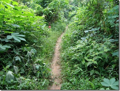
You never know what you will be stepping on. The rest of the trail was well "developed".

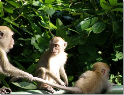
Apart from the snakes and (which I believe to be) a monitor lizard the only other animal that was abundant is monkeys in Riffle Range Road. They are so used to the place, they literally own it. Some stood right in the middle of the road - cars had to take a detour not to hit them! Birds were plenty and there were a few bird watchers as well.

PC130445 (1)

Once you enter the MacRitchie trial things are well organized (and I cannot believe I still got lost!). Well marked trials which are wide enough drive a car through in most places, abundant maps, few rest places all prim and proper.

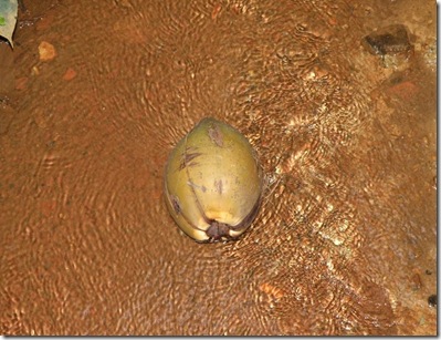
I wonder why most of the streams in the forest area are red in colour. Is it red algae or something else?

PC130501 (1)

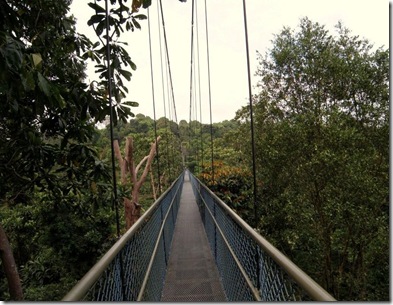
The Treetop walk starts with a serious climb from the Ranger Station. It is a one way circular trial. At the entrance of the treetop walk there is even a person sitting there to ensure no one walks back.

PC130476 (1)

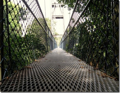
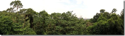
The Treetop walk gives you a magnificent view of lakes and the forest canopy. It sorts of sways a little bit as well.

PC130478 (1)

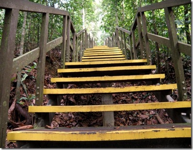
One the other end there is some climbing down to do - but well laid out steps are there.

PC130494 (1)

And finally you reach MacRitchie Trial (pink one) and then back to Ranger Station. The whole walk from the nearest cark park (Venus loop carpark) should be close to 10 kilometres and with some serious climbing and steps, it is not for the weak or disabled. The one way route makes it difficult to change your mind half way as well.

PC130473 (1)

The next part is the fun part. I walked round and round (as you can see in this map), but did not find my way to MacRitchie. I ended up at the entrance of Singapore Island Country Club and a kind security person gave me directions and advice to get back into the trial. I still didn’t make it to MacRitchie. I ended up taking a deserted track and finally ended up in this neighbourhood.

PC130508 (1)

Some tips before winding up:

1) Avoid Kampong trail; if not walk with someone else. There are snakes - some are big and long - and crawling too close for comfort. I am not experienced enough to determine whether they are poisonous or not.

2) It will be easier to walk from MacRitchie to Bukit Timah than vice versa. This is because Treetop Walk is a one way route. If you do the Bukit Timah to MacRitchie walk you will walk an "extra mile". Do so only if you love to walk!

3) When you have lost your way in the middle of a lonely jungle trial even a good GPS (even a Nokia N95) is not good enough. Try talking to people (if you manage to find one).

Sunday, December 14, 2008

Coast to Coast - Walking distances

Approximate walking distances each day for the "Coast to Coast" walk covering the whole distance in 14 days.

Day 1 St. Bees to Ennerdale Bridge

22.5 km

Day 2 Ennerdale Bridge to Rosthwaite

22.5 km

Day 3 Rosthwaite to Grasmere

14.5 km

Day 4 Grasmere to Patterdale

13.0 km

Day 5 Patterdale to Shap

26.0 km

Day 6 Shap to Kirkby Stephen

32.5 km

Day 7 Kirkby Stephen to Keld

19.5 km

Day 8 Keld to Reeth

17.5 km

Day 9 Reeth to Richmond

16.5 km

Day 10 Richmond to Ingleby Cross

35.5 km

Day 11 Ingleby Cross to Clay Bank Top

20.0 km

Day 12 Clay Bank Top to Glaisdale

29.0 km

Day 13 Glaisdale to Littlebeck

13.0 km

Day 14 Littlebeck to Robin Hoods Bay

18.0 km

Total Coast to Coast walk

300 km

Add a "free day" in the middle (activities for the day include laundry, foot massage etc. :) ) and travel to St. Bees and return from Robin Hoods Bay - one needs 18 to 20 days to do this walk.

Tuesday, December 9, 2008

Southern Ridges

And today I walked the "Southern Ridges". Starting at Harbour Front and all the way to Clementi - approximately 20 km in 4.5 hours.

http://sportstracker.nokia.com/nts/workoutdetail/index.do?id=559707

It definitely is not the usual walk. With ups and downs, (almost) real forests, lonely roads and some stunning bridges it was a "real walk".

PC090302

PC090331

PC090333

PC090369

I could have done it in 3.5 hours and 18 km - but unfortunately I lost my direction a couple of times. The maps enabled N95 phone is a saviour (once you know that you have lost your way).

The start point is Harbour Front MRT station exit D.

PC090291

The first phase is a steep climb - all the way up to Mount Faber.

PC090292

On the way there are some very interesting and old colonial buildings. Things I never knew still existed in Singapore. One of them even had a (somewhat dirty) swimming pool.

PC090297

After Jewel Box there is an interesting church - Danish Seaman's Church at 10 Pender Road.

PC090316

And this is where I lost my way for the first time during this walk. Throughout the trial directions are written on the walking track - which is very nice. But because of this I did not see a big board that said take right here - and that too a real big and brightly coloured board! Instead I walked through a road which has no pedestrian walkway for about a kilometre downhill and then once I realized the mistake (realized I am heading to an expressway) all the way back uphill. Need to improve my navigation skills.

Then comes the Henderson Waves bridge. 75 meters above the sea level (N95 says 84 - not sure whom to trust!) it is one of the most unusual architecture icons you can see in Singapore.

PC090319

PC090332

After the bridge passing the old Alkaff Mansion comes Forest Walk.

PC090343

PC090351

Here you have an option to come back to earth

PC090368

or continue to Alexandra Arch Bridge.

PC090375

Then comes the "Hot Park", the gardening hub of Singapore.  Never been there before - looks a wonderful place, especially for kids as the place has a lot of playgrounds. There are also many glasshouses - but all seemed to be closed. 

PC090382

A long walk and some climb later it is Canopy Walk at Kent Ridge.

PC090394

PC090395

From the Canopy walk you can see some some very unusual views of Singapore.

PC090407

Reflections at Bukit Chandu is next ($2 entrance fee). After such a long walk a short break at the air conditioned environment at Bukit Chandu is a relief from the heat and humidity. Watched a 20 minute show there which had some great sound effects.

PC090413

PC090415

And now back to civilization to Science Park I. Felt strange walking there - not many people "hike" in Science Parks.

And then to NUH where there is a lot of (MRT) related constructions are going on.

PC090424

And then to NUS

PC090427

And finally 4+ hours later at Clementi!!

And winding up with the most "unusual shot of the day" - A car park with a battle tank!

PC090422

Monday, December 8, 2008

It is raining

I am waiting for the rain to stop - so that I can start walking. If weather gets worse I will have to walk on a treadmill!

In the meanwhile I found a nice website about a person who walked from south to north of Great Britain. He has a nice e-book also there about this walk.

http://www.landsendjohnogroats.info/

And later that day....

I walked 15km in the rain!

Saturday, December 6, 2008

Planning

Always have a plan. At least you then know how much behind you are.

When:

So when do I do my coast to coast walk? Looking at other things in life which I have to do (like doing my job!) a good time would be between August and September 2009 or April – May 2010. Wow – what a long term planner am I!

Why is year end a bad time for this walk – it will be very cold and there would be some snow too (?) and days would be very short. Less time to enjoy - that’s not fun.

Why is mid-year a bad time for this walk – too many people walking. If I want to walk among lots of people I can do that in Raffles Place itself.

Why not April – May 2009 – There are other major things in life happening (which I will explain later). I also think I won’t be physically ready in another 4 months. I also must try a couple of short “long walks” before I attempt this – say a 50K walk over a weekend. This needs time to prepare.

Expanding Horizons:

It is strange I cannot find any good books of trekking, walking and hiking in any of the book stores in Singapore. I tried MPH, Borders etc. with no luck. As I couldn’t find any good books in the bookstores, I have downloaded (my first investment US$ 4.20 – I plan to keep track all my expenditures about this walk diligently) a chapter of “Walking in Britain” from the lonely planet website (Finding the whole book in the library for free later that day – Priceless!). I have also taken a few other books about trekking from the library and I am going through it now.

On a separate note...

I have covered 50Km over the past 5 walks.

http://sportstracker.nokia.com/nts/user/profile.do?u=masug